Shropshire Hills - Blacksmith Walk

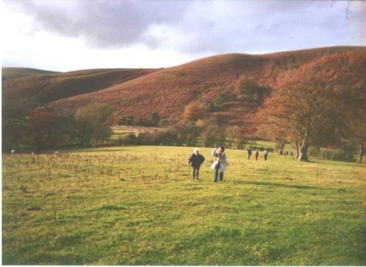
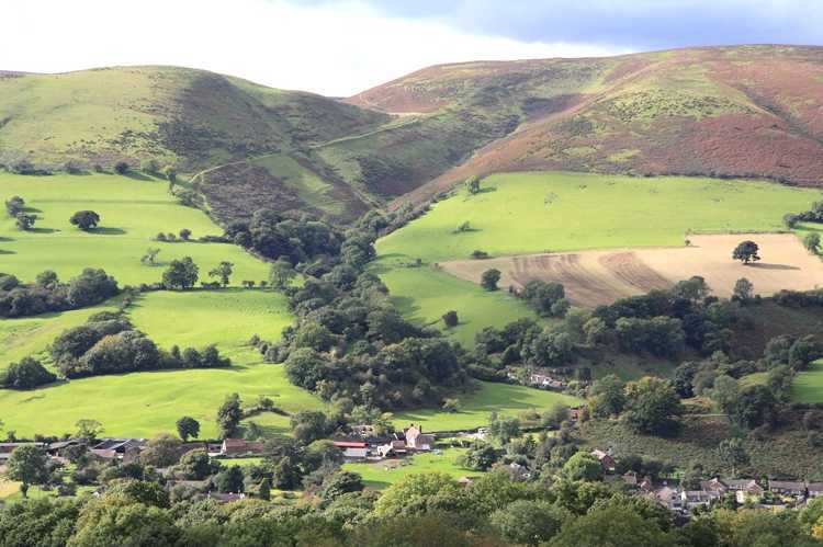
The Blacksmiths Walk – By Alan Garner This walk is called locally "The Blacksmith's Walk" and follows the route taken by the heavy horses that worked the land around Acton Scot Hall and its farms. They walked the five miles into Church Stretton to have their shoes replenished. The walk rises through the small valley in Snatchfield farm, and proceeds on the north side of Ragleth Hill. After that, its rolling farmland with the occasional stream to cross before reaching Acton Scott Victorian Museum once the home farm of Acton Scott Hall. Th return n route to Church Stretton skirts Ragleth Hill and through Little Stretton back to your start. Fabulous views to the east over Wenlock Edge and the Clee Hills. This walk commences at Church Stretton railway station and ends at the Acton Scott Victorian Farm museum (an alternative return walk is also appended). The walk starts on the east side of the Church Stretton rail station, - the side that trains arrive from Shrewsbury. Take right hand bridle path on the right between houses, starting to climb upwards into a housing estate. Continue footpath to a track bearing slightly left with many footpath signs on the post, and follow the signs for Ragleth Hill Walk, to a large gate, and proceed with a small field on your right, to reach another gate, then the abandoned Snatchfields Farm. A further gate leads to pastureland and take the easily followed path which eventually curves slightly left into a narrow gully and reach a gate just in the tree line. As you enter the gully, turn around and see excellent views of Church Stretton, The Cardingmill Valley, Burway Hill and Church Stretton Golf club.
Cross the stream and continue the path up the line of the stream on your right to reach a large gate, through this and proceed to the road. You will see a footpath marker and signpost in front of you, and directly behind it, and hidden by trees is a stile. Go over into a large field and proceed diagonally to the opposite corner of the field. Cross stile into road and ignore left turn to Hope Bowdler, but proceed left along the road for 600 metres. The road eventually bends right then left, ignore footpath signs to right, and follow the road slightly down hill, past Chelmick Farm on the left and small duck pond on your right. This is Chelmick hamlet, and 20 yards before the road bends slightly left, take the clearly marked bridle path (Wagoners Wander) on the right into a track. Ignore the track for Acton Amble. After 200 metres the track ends at a gate, Superb views over Brown Clee to your left, Titterstone Clee centrally, the lower Wenlock Edge ridge line running right to left and Flounders Folly – a tower standing on Callow Hill slightly to your right, with an interesting history Flounders Folly Proceed through the gate and keep the field boundary on your left, follow the fence line as it bends to right following Ride UK signs and then after 100 metres, drops down slightly to left and to a large gate, with Rag Batch on your right. The bridle path – with Ride UK signs on it – drops sharply down towards the stream coming from your right. Cross this stream, ignoring the bridle path on the left. Turn half left and proceed through gate into a field. See another field boundary straight ahead in 100 metres and a gate. When you reach this gate the footpath signs take you sharply right along the field boundary, and go slightly uphill for 100 metres, before the path flattens out, and at the hedge line in front of you, turns right for 15 metres. Proceed down in the stream bed on your left, cross a footbridge. Through gate and proceed on bridle path – still Ride UK - slightly left and gently upwards, enclosed by trees and vegetation. This path leads to an open field with a stile that seems unused – pass it and with field boundary on left after 150 metres, walk into a gully (again signed Ride UK) which can be quite overgrown in summer and autumn. This gully, 250 metres long, is enclosed and leads to a gate and another small stream course. Over the stream and turn slightly left to large gate into field. Follow the track slightly upwards to reach a large gate into the road from Marshbrook to Ticklerton. Victorian farm museum is 150 metres to the left, but here we turn right. Passing Acton Scott Village Hall on left and at crossroads, take left turn. After 75 metres, you see the Acton Scott Victorian Farm museum and café on left, look out for stile in hedge on right – the sign is the Shropshire Way Circular Walk sign – green. Cross stile and to right hand side of field just past a large tree, find a stile/gate. Through this and cross diagonally the next field to another stile. Proceed forward with a small bench raised slightly on your left and a finger post slightly raised on the small hillock in front of you. Past finger post, and bear left to highest point, then turn right with fence on your left. 100 metres on, in the fence line on your left, find a gate into Acton Scott Churchyard. Round the church to its right and to ornamental gate. Reach the minor road with Shropshire Way signs on footpath post in front of you. Turn right for 150 metres, then follow Circular Walk signs, turn left on to broad track. At the third field boundary, turn left again with Shropshire Way circular signs, and through one field stile and then after 100 metres, bear slightly left to gate. Through gate and walk up hill towards copse in front of you and in 100 metres at tree line turn right, follow boundary fence, eventually to the end of the copse. Acton Scott Hall is visible to your left as you reach open views to the left. Continue for 200 metres, a small finger post by a large tree, points you to a stile in the fence on your left. Through this and bear slightly down hill and right to another stile. At this stile, turn left and keep the fence line on your left to reach another stile into a narrow tree lined gully. Bear right and slightly uphill to reach a stile into an open field. Diagonally across this field to another stile, again on your immediate right you see the front of Acton Scott Hall. Across this stile and into the grounds of Acton Scott Victorian Farm - toilets by reception here. Go out to the minor road and turn left. From the Victorian Farm, turn left and proceed uphill to crossroads and turn right, signed Ragdon. This is the Shropshire Way. (on the outward route you will have entered the lane opposite Acton Scott Farm, so here you are repeating a very short stretch of the outward route). Follow the road for ¾ mile with lovely views of Ragleth Hill in front of you and the LongMynd on your left. Wenlock Edge can clearly be seen on your right as well as Brown Clee in the distance.
When the road bends sharp right at Toad Hall – turn left on to small bridle way and proceed downhill, past buildings on right and an old water pump at the side of the path. In 250 metres, proceed through gate and then along field boundary on your left. The path curves to the right, dropping slightly down hill and to another gate and then into a wooded gully. Go down this gully for 150 metres to a gate with a set of stables in front of you. Keep the house on your left and onto tarmac area through a gate – normally open – and proceed to main A49 road. (Alternative route – at Toad Hall sign -, follow the road round to the right, 20 metres along on the left, the Shropshire Way is signed left, go over stile and keep on through another stile, going slightly downwards. The route then goes steeply down and to your left, then bends right, and eventually after 300 metres reaches a memorial grave on your left. Continue forward to meet metalled road, and the above route, and bear right, to main road.)
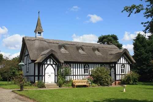
The village has two superb pub restaurants, see the Green Dragon on your left. Cross road and follow a sign to village hall alongside the Ashes stream. Past minor road on the left, and farm on right, and to junction where you take a right turn back to the road. The thatched church is on your right, and the Ragleth Inn on your left – turn left and walk along pavement until the road reaches open land on both sides. (300 metres) Follow the road a further mile into Church Stretton. Here you have many shops, cafes and pubs. You have a choice of ways to reach the railway station. The walk length is 8.5 miles. Another option is to proceed to bottom of Ashes Hollow and take Nisbets Way to meet Little Stretton – Church Stretton road. Turn left and walk the half mile back to Church Stretton or bear left and uphill to the back of Longmynd Hotel. |