Wales - Abergavenny
The Sugar Loaf Mountain from Abergavenny - By Alan Garner
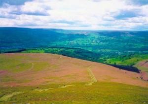
Peering between the ridges of the Llanwenarth, Deri and Rholben hills, the Sugar Loaf is one of the highest peaks in the heart of the Black Mountains. It stands at 596m high and offers glorious panoramic views across South Wales, the Brecon Beacons, and into south-west England.
Its conical shape is reminiscent of a volcano, but the mountain is made of the same old red sandstone as the rest of the Black Mountains.
The gentle, rounded heather and bracken-clad shoulders of the mountain are criss-crossed with paths and provide an exhilarating place to walk and take in the landscape’s rugged wilderness, throughout the year.
The route we have chosen is the shortest route to the summit. There are many paths which radiate out from Llangenny – close to Crickhowell, which afford a longer route to the summit.
Our walk is close to Abergavenny town.
Yes - it’s a climb but well worth the effort.
The main access point onto the Sugar Loaf is from the car park on the Llanwenarth. From here you can head for the summit,
The Sugar Loaf is not quite a mountain as at 596m high it misses out by just 4m. Yet despite this, the view from the summit is a real bonus.
It can be extremely busy as it is close to the delights of Abergavenny and the South Wales valleys, avoid the weekends if you want a stunning but peaceful walk. But there’s plenty of room with the network of paths to largely avoid the crowds, except for the summit of course!
The route up the Sugar Loaf starts off from the National Trust Car Park at SO268 167 reached from Abergavenny from the A40. No facilities here BUT parking is free.
Take the signposted path opposite the car park, leading beside Porth y Parc farm and through 2 gates. Go slightly downhill and over a stile beside a gate.
The path begins to rise. Go over another stile/gate alongside some trees. After another gate/stile you come to an area of parkland scenery overlooking a pretty valley (shown on the map as "The Park").
Where the path divides take the left fork. Go over 3 gate/stiles in succession - alongside a wood. The path follows the edge of a wood. The summit is visible at this point but stay on the path until a fence comes in from the right.
Turn up the hill following the trail through low gorse and heather. Where the path splits you can go straight up or follow the right fork and loop round to approach the top from behind. The loop route offers a steadier climb and wonderful views across to the Bristol Channel.
Once at the summit, you can spot alternative ways down the mountain, but also your way up can be your way down.
.jpg)
The summit is an elongated ridge reaching 1,612 feet (496 metres) at the trig point, which is at the western end. The conical shape that earned this mountain its name is apparent from the narrow ends of the ridge.
Follow steps down from the top to join the steeper of the summit paths back to the fork where the loop path began. On approaching the woods veer left until you reach a stile, which crosses the fence into oak woods (few woods boast this many oak trees).
Go across a stream and through a gate, then through another gate and over another stream. Follow alongside a fence and retrace your earlier path alongside the woods and down towards Porth y Parc farm and the Car Park.
.jpg)
Abergavenny -
Don’t forget to visit Abergavenny – there is a song from the 60’s about the town, Marty Wilde: “Taking a trip down to Abergavenny, hoping the weather is fine”
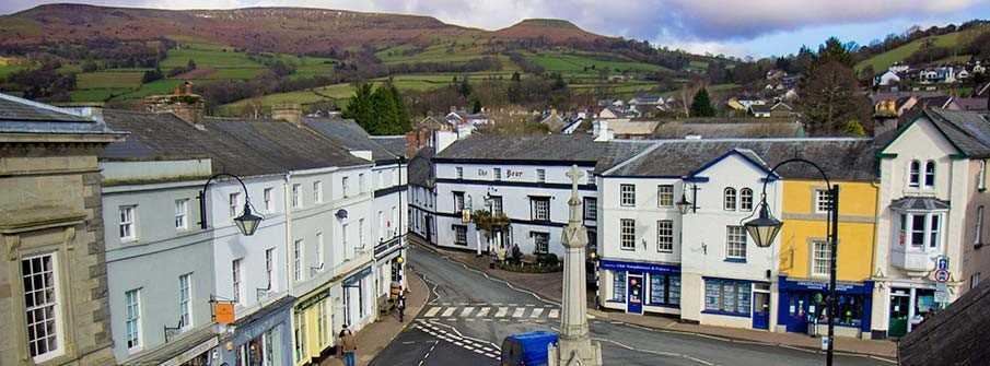
Abergavenny is located in the heart of the Welsh Marches on the southern edge of the Brecon Beacons National Park. This ancient and welcoming town is the ideal centre for a truly wonderful, refreshing holiday, whether it be a short break at any time of the year or a longer leisurely stay.
Abergavenny is a great place to stay when exploring all that the Brecon Beacons and the Black Mountains have to offer, from some of the best hill walks in the world, to horse riding, mountain biking, adventure weekends and gliding. Offa's Dyke and the Marches Way also pass by the town, whilst the Forest of Dean is only a short drive away. The town itself, caressed by the Brecon Beacons and Black Mountains and nestling in the famous Usk Valley, is full of historic, architectural, cultural and scenic interest, proud of its past and its traditions.
Since the 12th century, Abergavenny has a proud of a history that takes in the infamous Norman Marcher Lords, the Glyndwr Uprising and the Civil War. This tumultuous past is etched into the ruins of Abergavenny Castle and chronicled in the local museum.
The jewel in Abergavenny's crown is the Abergavenny Food Festival in September attracting top chefs and food critics; the Festival reflects the local produce with a reputation as some of the most sought after and fashionable ingredients in the world. If your visit doesn't coincide with the Festival however, the shops, monthly farmers market and many of the town’s restaurants will give you the opportunity to savour Abergavenny's finest food.
For those interested in the industrial history of the region, the nearby town of Blaenavon is a World Heritage Site with a number of museums and interactive experiences.
Abergavenny castle was built in 1075 as a Norman stronghold in the contested territories around Offa's Dyke. Exactly 100 years later it was the site of a massacre as William de Braose decided to seek retribution on local chieftains by summoning them to the castle on Christmas Day and then brutally slaughtering them. During WWII Rudolf Hess, Hitler's deputy, was held at Abergavenny Hospital where he spent time making paintings of the surrounding countryside.
The Tourist Information Centre is located at the Bus Terminal in the town centre. Abergavenny has a railway station on the South to North Wales route between Newport and Shrewsbury.
The Black Mountains of South Wales are a group of hills spread across parts of Powys and Monmouthshire in southeast Wales, and extending across the national border into Herefordshire, England.
They are the easternmost of the four ranges of hills that comprise the Brecon Beacons National Park, and are frequently confused with the westernmost, which is known as the Black Mountain. To confuse matters further, there is a peak in the Black Mountains called Black Mountain.
The Black Mountains may be roughly defined as those hills contained within a triangle defined by the towns of Abergavenny in the southeast, Hay-on-Wye in the north and the village of Llangors in the west. Another 'gateway' town to the Black Mountains is Talgarth
The highest mountain in the group is Waun Fach whose heavily eroded peat summit plateau attains a height of 811 metres (2,661 ft). Other significant summits towards the northern edge of the range include the 703 metres (2,306 ft) peak of Black Mountain with its northern outpost of Hay Bluff (Welsh: Penybegwn),[3] 677 metres (2,221 ft), Rhos Dirion, 713 metres (2,339 ft) and Lord Hereford's Knob or Twmpa, 690 metres (2,264 ft). Towards the south of the range are the more independent summits of Crug Mawr at 550 metres (1,804 ft), Pen Allt-mawr at 719 metres (2,359 ft) and the 701 metres (2,300 ft) peak of Pen Cerrig-calch which rises prominently above the Usk Valley.
Outlying summits, all of which are classed as Marilyns, include the Sugar Loaf, Mynydd Troed and Mynydd Llangorse. The lower and separate hills of Allt yr Esgair, Myarth, Bryn Arw and Ysgyryd Fawr (also known as 'The Skirrid', Skyrrid or 'Holy Mountain') are scattered along the southern fringe of the Black Mountains.
Crickhowell is a small market town with many individual shops, ancient inns and plenty to do for visitors and residents. Surrounding Crickhowell are the picturesque villages of Llangattock, Llanbedr, Llangenny, Glangrwyney, Tretower and Cwmdu, each with its special character.
A settlement has existed here at least since iron-age settlers built a fort on the top of Crug Hywel, also called Table Mountain after its flat top. In the town a motte and bailey castle, remains of which still exist, was built by the Normans.
A well-known feature of Crickhowell is the bridge spanning the River Usk. Built in 1706 and modified in 1828/30 resulting in thirteen arches on the upstream side, with twelve on the downstream side.
Another historic feature of the town is The Bear Hotel, a former coaching inn which retains its ‘post horses’ archway and original cobbles.
There is plenty to do in and around Crickhowell. The annual Art Trail of studios and galleries during the Spring Bank Holiday weekend gives access to a surprising number of artists in their studios. And the Walking Festival in February – March provides a range a walks for all levels of ability – a great introduction to the many and varied walks available in the area.