Snowdonia - The Cnicht
Snowdonia – The Cnicht from Croesor - By Keith Oxby
While most people head for Mount Snowdon when they want a memory of their visit to Snowdonia, another less travelled option is the Welsh Matterhorn, shown on the map as the Cnicht and part of the Moelwyn hills. The name Cnicht is an old English word for a knight’s helmet, and so the mountain doesn't have a Welsh name.
A true mountain at 2,260 feet (689m) and although some say it’s actually a ridge, it makes for a memorable climb.
Located just south of Snowdon in the beautiful Croesor valley, and a short drive from either Beddgelert, Ffestiniog or Porthmadog. It can be reached from Nant Gwynant via a longish route, or more simply from the National Trust carpark (grid ref. SH 631446) in Croesor. The CP is free and there is a portable toilet.
.JPG)
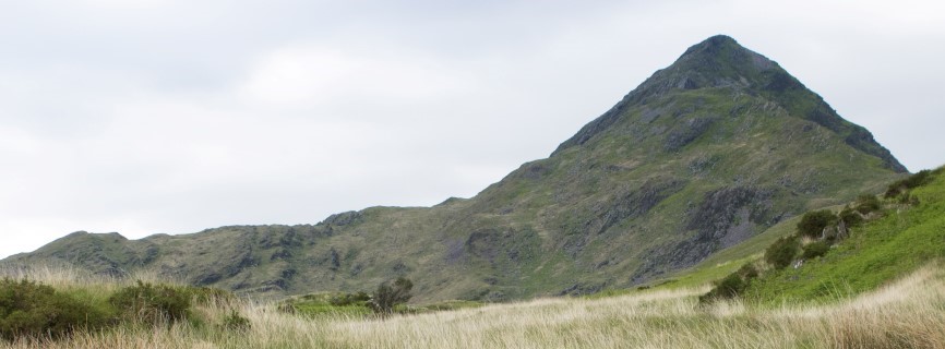
The route described is from Croesor and after leaving the CP turn right on the road up the hill and through the village. The road becomes a cobbled track passing through some trees and then towards to the top of the hill, turn right onto a footpath.
After joining the FP you will be greeted with a view of the Cnicht summit and see why it is often referred to as the Matterhorn of Wales. Use the summit as your reference so you don’t deviate onto a path that leads off to the left, which is actually the return part of the Nant Gwynant to Cnicht route.
The path is grass covered initially, although the higher one climbs, the more rugged it becomes and the final push to the summit is something of a scramble. Before the final stretch, there are opportunities to look down into the Croesor valley over to your right.
The track continues to steadily climb along the north flank of the mountain, with a few stiles before climbing steeply to the summit. As said, the last section is a bit of a scramble with no distinct route, so select the path you feel most comfortable with, even going slightly left or right.
Once at the summit, take time (if weather permits) to take in the western view over to the Irish Sea and the Welsh coast. To the NW you should be able to make out the summit of Snowdon. The beautiful Croesor valley is to the SE and you won’t find a more picturesque valley anywhere. On the other side of the valley is the dominant peak of Moelwyn Mawr, standing at 2,530 feet (770m), a designated Site of Scientific Interest (SSI) and is wonderful climbs itself.
.jpg)
The Croesor Valley with the Cnicht on the left and Moelwyn Mawr the right
Author Patrick O’Brian who wrote the Aubrey/Maturin series of seafaring novels set in Napoleonic times, lived in this valley for some years.
After leaving the summit, head NE along the ridge to the southern shore of Llyn yr Adar, with the Ysgafell Wen range of mountains in the distance. The path is reasonably well defined, although take care if cloud closes in because there is a drop-off on your right.
.JPG)
A lonely pair of boots and no sign of an owner
This is remote country and it’s unlikely any other walkers will be encountered. The path, in places is very vague, and leads SE towards Llyn Cwm Corsiog. Continue past the Llyn, keeping it on your left and head towards the slate workings, picking your way across the marshland as there isn’t a distinct path.
.JPG)
From the Cnicht to Llyn Cwm Corsiog
Once in the slate quarry, take a bearing on Llyn Croesor, and follow the path, again keeping the Llyn on your left. There is an option to descend into the valley and Llyn Cwm foel, although it is a very steep tramway ramp, and the recommended route is to pick up the old tramway which gently descends the south side of the valley.
There are tremendous views of the valley and the ridge you followed from the Cnicht.
Eventually you will reach the valley road and have the option of either turning left and following the road back to the CP or continuing on the FP to the stream, turning left on the path towards the CP. There is a tea room just after reaching the valley road, although the author has yet to find it open.
Total distance is about 7 miles with an ascent of nearly 2000 feet as you’ll be starting from almost sea level. The ground is generally firm, although the final stretch to the summit is rocky, and the section after leaving the ridge and reaching the slate workings, can be boggy. Weather can change on the mountain, and cloud can very quickly cover the whole range, so ensure you have a compass and map (maybe a gps too).
.jpg)